Sony is ready to launch a GPS module

Sony can make GPS work. They pioneered it in the A55, refined it in the A77, A65 and A99 – and abandoned it without a word in all later A-mount cameras and the entire E-mount series. But they prepped the Multi Function Accessory Shoe to be used with a GPS module – and I believe it will be on the market soon.

They have put the rest of the architecture into the new cameras to make a GPS hardware module for the accessory shoe possible, practical, easy to implement and maybe even affordable (especially if third party makers come to the party).

This is a simulation using a retouched Elinchrom Skyport trigger – about the smallest size a GPS could be expected to be. For accuracy, something twice this scale mounted on the hotshoe would be a powerful four-aerial 2xAA cell or lith-ion powered GPS receiver.

Sony have added the I/O part of the data flow which puts geo data into the metadata fields of image files to the processor of the A9, A6500, RX10 MkIV (I think) and now the A7RIII – and in all three, they’ve put a 2.4GHz Bluetooth I/O process which can communicate with smartphones running their own GPS tracking app and grab the data every time you press the shutter. It needs no additional app on the camera.

This is significantly different from the Olympus solution (above), which I have also been testing alongside Sony’s. I have not found the A6500 pairing with iPhone all that reliable or persistent between sessions out of range or turned off. I have not enjoyed the Olympus method either – you synchronise the phone GPS app timecode and the camera time setting once using WiFi and after this you can turn WiFi off on the camera, leave the tracking app running on the phone, and shoot. At the end of the shoot, you connect again to the camera and initiate a transfer of the GPS track to the camera, which then parses it and embeds the co-ordinates closest to the timing of each exposure into the image files.

Sorry if this sounds a bit complex but it’s not. Essentially, Sony maintains a live link to the phone while you are shooting and acquires the GPS data to embed every time you make an exposure. Olympus relies on time synchronisation and an ‘end of day’ in-camera, wireless addition of the GPS data not unlike the process you might use with a separate tracker and a program like HoudahGeo or Photolinker.

That shoe has a GPS data channel – so far, unused. Now the processor has everything needed to make it work.

What’s really, really important is that these new Sony models have the firmware, interface connections and data handling to acquire a real-time or most recent position data packet from a stream, and inject this into your .ARW and .JPG files without needing any time synchronisation. Other models, which can not use the phone/Bluetooth solution, presumably do not have this firmware and the built-in protocols for acquiring, writing and validating. They don’t have the ready-made menu options either.

So, in place of your Bluetooth phone GPS, you will hopefully be able to fit a camera-top GPS module similar to those used by Canon and Nikon (who built the GPS data writing ability into their firmware years ago). The connections have been in the MFA shoe since 2010. Now the new camera models complete the jigsaw. All we are waiting for is for Sony to release a GPS module and a minor firmware update (the menu entries are already there). If the GPS module has its own battery, all the better – my tests with iPhone and A6500 ran the batteries on both down so fast the method would be impractical for anything more than day-trips.

I use GPS – at the moment, synchronising a track from an iGotU GT120 tracker carried in my camera kit or in a pocket. The device is not very reliable, has dodgy Windows-legacy management software and basic Mac function via third party programs. But for the travel photography I sell, captions have to be accurate and detailed, so the effort has to be taken. It was all SO much easier with the A55, A77 and A99… not to mention the Nikon D5300, Pentax K-1, or Sony’s non-raw-enabled Cybershot HX400V, HX60V and so on. For a very short time indeed I used the Jobo PhotoGPS, which required connection to a server database to turn its satellite position values into geocoordinates. Someone forgot to renew the licence, the server owners turned off the service, and every single PhotoGPS unit sold became a paperweight.

Nothing really beats having in in-camera or on-camera – and Sony has a good record of providing GPS assistance data files, auto-loaded on to your memory card when needed, which make the few cameras provided with GPS work well.

I had almost decided not to consider the A7RIII, but if my prediction proves right and the GPS module arrives in 2018 I will buy one. I’ve actually sold my A6500 after just three months of use to spend a bit of time using an Olympus E-M1 MkII outfit, including its slightly less battery-intensive GPS kludge. I’ve kept my A7RII as no camera made on the market at present, which is comparable in format, attains an image quality to match it when all other factors are equal.

Disclaimer: this is speculation. But it’s not empty speculation!

  • David Kilpatrick


A57 – no GPS

A57 announced today does what was needed and updates the A55 to have a decent EVF, plus a few bells and whistles. It’s got a 77-style microphone, and also a mic input socket for external mic moved to a better position than the A55. It has full 1080/50p video capability, 12 fps burst mode (with the usual restrictions and more*), a 15-point 3-cross AF sensor like the A65.

This camera is not an A55 body revision – it uses the NP-FM500H battery, the larger size found in the earlier A5xx-series Alphas and the A77/65. This should give it far more shots (well, OK, 550) per charge than the smaller ’50’ size battery used by the NEX and A55/33/35 etc. Sony’s new accessories include an LED video light, HVL-LE1. The rear screen is similar to the 55, reversible to the body (one of the major points missing from the NEX-7, which cries out to be configurable that way but can’t be).

Exposure bracketing remains limited to the inexplicable and disappointing 1/3 or 2/3 (0.7EV) steps and just three frames, so for HDR you are obliged to work manually or use the camera’s  JPEG-only function.

*You only get 12fps in the ‘tele-zoom’ mode which is effectively a 2X crop to a mere 4 megapixel image, optimistically interpolated up by Sony in-camera to create a redundantly oversized not quite sharp enough JPEG in ‘tele-zoom’ mode. Otherwise, you get the usual and impressive 8fps regular and 10fps ‘advance priority’ modes, plus a 3fps Lo speed.

But they have dropped GPS, unless someone has managed to miss it out from the specs. Oh well. Not that interested now. Disappointing. Potentially much improved travel camera – one I would prefer to the Alpha 77 for size, weight, and sensor – turned into a family camera with some neat joke functions like automatically cropping portraits and then blowing up the cropped area to 16 megapixels. This uses face recognition, a variation of the tele-zoom kludge, and what could be a very annoying Rule of Thirds composition adjustment – at least it also saves the original file with the face/s placed where you intended. The best thing about features like these is that you can turn then off, the worst thing is that Sony probably think this is more useful than GPS.

Available end of April, and we shall be rushing out to avoid this model and wait for the next bus to arrive. Everyone has been saying – we’d love an A77 or even an A65 with the 16 megapixel sensor. Or we’d love an A55 upgraded with the better viewfinder. So what do Sony deliver? Neither…

Hopefully I should have put ‘yet?’ after that last remark.

– DK

Watch the birdie – will Sony’s GPS surprise?

Before reading this article, which has attracted a lot of traffic and attention, please remember this is my personal speculation and could be entirely wrong (I’ll be very disappointed if it is miles off target and they omit GPS… or my reading-between-the-lines turns out to relate to a different product like a superzoom pocket camera with improved GPS).

There are plenty of detailed rumours about the specifications of the forthcoming Alpha 77, Alpha 65, NEX-7 and NEX-5n to be found on the Sonyalpharumours website:

http://www.sonyalpharumors.com/sr5-the-full-a77-a65-nex-7-and-nex-5n-specs/

I’m not here to confirm or deny any of this (like most mainstream journalists, even those with some connection to Sony, I don’t get advance information and I am not running a camera-test website which demands a pre-production preview under strict non-disclosure terms).

The image currently circulating most, purporting to show a new Alpha – 77 or 65. Real or not, it looks good enough.

The 12fps stated maximum shooting speed of the semi-pro specification A77 fits in with information given to me as long as three years ago. A vaguely Alpha 700 like prototype was being tested in the Australasia region with 15fps. Most of the other specifications, such as the magnesium or magalloy body, were apparent right from the first mockups being shown if you know your Alpha construction. The strap lugs were the giveaway. You can tell an A900/850/700 type camera (solid metal carcase under a plastic skin) from an A1/2/3/4/5xx Alpha by the strap lugs connected through the skin to the casting.

But what Sonyalpharumours doesn’t elaborate on its something I believe Sony has put into the new Alpha 77 which will make it the ultimate cameras for bird watchers, aircraft spotters, wilderness ramblers, explorers, police forces and the military. It has GPS. I think that when it is seen by the press later this month the GPS will be a big point.

It will be the fastest locking-on GPS built in to any camera, and it will be the first to record ALL the data you need. That will include not only the latitude and longitude and height above sea level, but also the compass direction the camera is aiming in and the inclination of the camera. Combined with very accurate focal length, focus distance and AF locus data, this will make it possible to use the Alpha 77 for photogrammetry (measurement, mapping, object size identification).

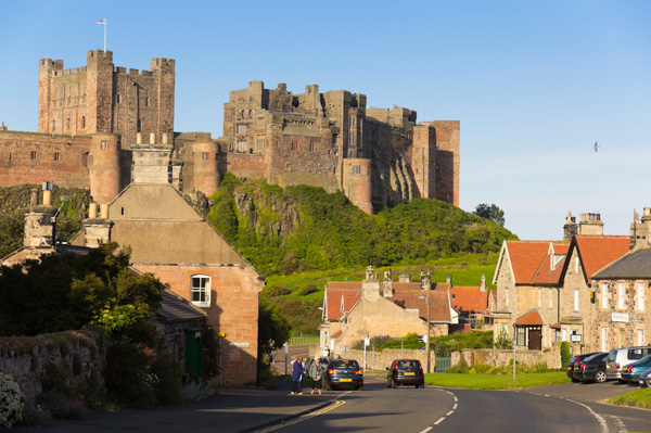
I parked illegally and jumped out of the car for this shot of Bamburgh Castle from the village’s main road. For once, the Alpha 55 GPS locked on instantly and gave me the exact location of the camera on the Google Earth terrain view below.

But two days later I spent ten minutes, using a tripod, carefully photographing an uncommon slightly edible mushroom in our garden over 30 miles from this shot. Needless to say, all the frames of the mushroom display the GPS data from Bamburgh as it had failed to update its position.

This is Leucoagaricus nympharum – white field mushroom with ‘dancing maidens’ on its distinctive cap. Some sources state it is edible. For me, it was. For Shirley – noted as one to avoid for the future… but a great photographic subject. Natural light, CZ 16-80mm, 1/3rd of a second at f/14, 80mm, ISO 100, manual focus and settings.

The GPS in my Alpha 55 has been a real help in travel photography. I use Media Pro, the Phase One cataloguing and keywording software. Since this moved away from Microsoft ownership it no longer has its own own Microsoft Virtual Earth pane to open when GPS embedded data is found. Instead, it opens my web browser to the usual Google Map and Earth page. It’s not as neat as having the map tab within the Media Pro software but it works just as well.

However, the A55 GPS frequently doesn’t get a signal during many minutes of shooting at a new location. I have entire shoots of places, lasting several minutes in clear open conditions, wrongly tagged for the last spot visited. Fortunately, if I have left the camera switched on I sometimes find the correct location attached to the next place en route…

The Alpha 77 will, I believe, see an end to poor GPS and it will add the vital compass and inclination functions. Combined with the 24 megapixel resolution, near-silent mirrorfree high speed sequences, and the 1.4X and 2X teleconverter functions (cropping the sensor field but retaining full HD 1080p video, we hope) this will make the 77 the world’s best camera for wildlife safaris. And for those who like to log their natural history subjects, the accurate GPS tagging is the closest thing you can get to digital evidence of the authenticity of your shot.

All major camera companies have their eye on government and military budgets. It was the US forces’ decision to buy Topcon SLR cameras in the 1960s which gave that small but excellent camera brand a few years of glory. They achieved it by making a camera which was tougher and more versatile (in some ways) that the rival Nikon F – with accurate TTL metering that did not need a bulky prism head.

At different times Olympus, Nikon, Leica, Hasselblad and even Minolta have been favourites for government and military use. I think Sony, realising what the high resolution and very fast capture rate of their new technology mean to such users, will have sealed the deal by upgrading the GPS. The Alpha 77 will not only be the world’s best wildlife and wilnderness companion, it will also be the best evidence camera, surveillance camera and spy’s best friend.

Of course this is all pure speculation. It is based on a well-grounded hunch, and on what I would do myself, if I was in charge of the Sony development plan for the A77. There’s no way I would let another GPS module out in the world with less reliability than the average pocket digicam’s version. I would want my top SLR (SLT) GPS to be a world-beater.

Now you’ll just have to wait and see. But wouldn’t it be good if I’m right?

– David KIlpatrick

A dream of the future – and past

Sometimes earlier this year, early Spring I think, I had a vivid and detailed dream during a slow waking-up hour. It was the kind of dream which feels rational not random. I knew what I was doing in it – in control!
This time, I described the dream to my wife and son; he knows a lot about this stuff, and thought it was an accurate dream. It was possible. Now Sony is about to release the camera I was using in the dream.
Here is the dream.
I am walking across a kind of pier or boardwalk construction at the edge of water. It’s not in Britain. It’s warm and sunny, and it could be in the USA. The boards are raised above what would be the shore, and there are wooden buildings left and right of me. Ahead, I can see the lake water, and boat moorings with a jetty. To the left of me is the largest building, which is a shop or museum; something to visit. There are ornamental shrubs placed on planters or pots, and there are some notices or signs on the building. To the right, the wooden building is functional; it could be a boat house, a yacht club, or something like that. There are pine woods beyond.
My job is to move to the four corners of this scene, and other positions, taking care to make a complete set of images from a range of camera placements and angles. I’m using a wide-angle lens, and my camera is equipped with GPS which records the exact position and orientation of the camera for every shot.
I do not worry about people in the pictures because the software will ignore them, nor about the light, but it is a beautiful day anyway. I am taking the pictures for a project and this is paid work. This is actually what I do for a living (in the dream). I am visiting hundreds of the most frequently-photographed places in the world, and producing a set of pictures of each one.
But it’s not what I am doing which is the interesting bit. It’s what I know about it. In the dream, I have all the knowledge about what I am doing that I would have if it was real.
480 width ad:


Time and space
Here’s how my pictures are being used. Each set of images with its GPS coordinates is fed into a system which constructs a 3D model of the environment. It is capable of recognising identical elements seen from different angles, and uses the GPS data to help identify them. With two 2D views of a building from different positions, it can use the focus distance and lens angle information to compensate for small inaccuracies in the GPS data, and wireframe the exact design and scale of the structure.
It identifies textures and objects like foliage, text on signs, clouds, and people. Once my entire set of images from this place has been processed (I am aware they are being transmitted as I take the pictures) new photographs which never existed can be created. A virtual camera can be positioned anywhere within the area I photographed, and my few dozen still images from fixed positions enable a new view to be constructed with complete accuracy.
I’ve used the result (in my dream) and it has incredibly high resolution because of the correlated image information. It’s a bit like Sony’s multi-shot or HDR or panorama technology, but instead of aligning two very similar images, it maps the coincident key points of entirely different views of the same scene. Where a walk-through VR allows viewing all angles from one position, this allows viewing any angle from any position.
And it goes beyond that to add a timeline.
The system I’m working for gathers millions of photographs from people all over the world. I’m photographing these key locations because they are the most photographed in the world. Camera phone images now record GPS data, and also record the date. So (at this future time) do most digital cameras and video cameras.
The system can find images matching every location by trawling the web; from Flickr, Facebook or whatever is out there. It can analyse the images to see whether they actually match the location they appear to be from. For every location, the system gathers in as many more pictures as it can find.
The first result of this is more detail. The second is that the viewer can change the season or weather conditions in which the location is seen. It can be viewed at night, in snow, in rain, at sunset; whatever. My image-set provides the framework, but seasonal changes can be created from the ‘found’ images of the place.
The second result is the timeline. Old photographs of these places have been fed into the system. For some popular spots, it’s possible to track the environment backwards for over 100 years. Trees change size, buildings appear and disappear. By turning on ‘people’ (which the software can remove) the crowds, groups or individuals who were in the scene at any time can be shown. And the 3D environment is still enabled because all the old photographs are co-ordinate mapped to the new information.
I do not have to work all this out in my dream, because I already know it. I am working with this awareness. The entire thing is known to me, without having to think about it. I also know that future pictures captured from internet will continue to add to the timeline and the ‘people’ function, so in five years’ time the seasons and the visitors to this place can be viewed almost by the minute.
The dark side
Because this is a dream, I do not have to think or rationalise to get this understanding; it was included with the dream. As I wake up, I realise what I have been dreaming and then make an effort to ‘save to memory’. That also kicks in the thinking process.
I start to wonder who was hiring me to do this survey-type photography, because in the dream that is one thing I don’t know. I realise how exciting it is to be able to use this Google-Earth or Google-Street type application to view not only any part and any angle of these tourist locations, but any season or time of day, and many past times in their history.
When I describe it to him, Richard suggests it’s probably Microsoft. He likes the collation of web-sourced images covering seasons, and maybe decades of past time. He thinks it is all possible and the core technology exists right now. I should patent it and give it a name!
But there is one thing which I understood just as I was waking up; the system can recognise people. Not just as people to be ‘removed’ from a scene or turned back on; it can recognise faces. The movements of one individual can be reconstructed within that location, and it can use a ‘cloud’ of gathered pictures taken at the same time to do so. This is not just virtual tourism and virtual history. In other locations – not beautiful waterside boardwalk quays – it is surveillance brought to a new level.
Sony A55 and A580
Sony’s new models with built-in GPS are the first cameras which will record the data my dream required. The GPS is not the typical latitude-longitude only. It also records height above sea level (elevation) and the direction the camera is pointing (orientation). The camera-data information records the focus distance and point of focus, and the angle of view of the lens (focal length), the time, and the measured light level and apparent colour temperature. Maybe in the A55 the spirit level function also records horizon tilt and position.
OK, the camera I was using in the dream was more like a 5 x 4 on a tripod. But that could be just a dream – like the giant fish which leapt on to boards and brought the jetty crashing down into the water a second before I woke up…
– David Kilpatrick
480 width ad: