Sony GPS-CS1 tracker and software
THE FIRST QUESTION anyone asks about the Sony GPS-CS1 device is whether it will work with their non-Sony digital camera. The answer is yes but you may need to buy some extra software, as it only comes with software to link up to Sony Picture Motion Browser. If you can ensure that you buy the product sold as GPS-CS1KA it should include a copy of this software in full. If you buy the product coded only as GPS-CS1, it may have nothing apart from a patch-updater program you are supposed to use with your existing Sony installation. So make sure you know exactly what you are buying (there appears to be no price difference, and very few retailers are making any distinction between the two bundles). There seems to be no reason to continue offering the kit with the updater only.
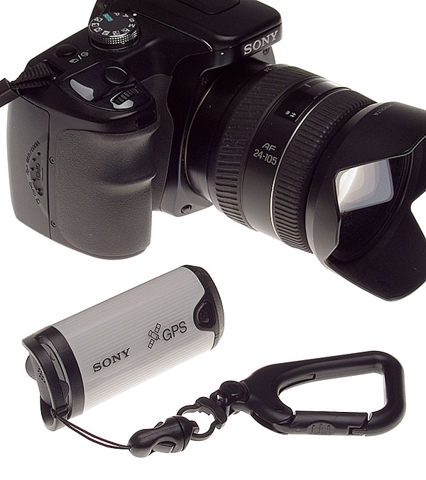
The Windows-only Picture Motion Browser program is provided with the Sony Alpha 100 and two Sony printers DPP-FP55 and FP35, but like most image-browsing utilities it works with all JPEGs no matter what camera was used to shoot them. The CS1 installer CD and a Sony website download will also update the older Sony Cybershot Viewer and replace it with PMB.
If you have Sony software already, or a GPS-CS1KA unit with its installer CD, you will be able to use any digital camera with the satellite tracking system.
First you have to understand that GPS positional recorder units are not magic. They can not provide any information for shots you took before you bought the unit, or any that you take without wearing or carrying the little pod and having it switched on. If the satellite signal is lost – which happens surprisingly often – any pictures taken during these periods can’t be linked to the data.
You must have a position log file created by the GPS-CS1, which automatically includes the time indicated by the satellite, and EXIF data compliant JPEGs taken with a camera while the unit was switched on, time-stamped to match periods when your map co-ordinates were recorded.
A single NiMH or high power lithium AA cell will run the CS1 for 14 hours, but regular alkaline batteries run down in minutes and must not be used. You switch the CS1 on, aim the rounded top side marked with the aerial symbol more or less at the sky, and watch until the light flashing twice every second (searching) changes to once every two seconds (recording). Then you just let it dangle from your camera strap or your belt via its carabiner clip, or pop it in the top of your rucksack or camera bag. I found it very sensitive to the state of the battery, and that a fresh AA lithium cell was by far the best answer to NOT having it die on you with alkalines or NiMHs. It will record your position every 15 seconds, as long as the aerial zone is more or less aiming upwards. Since it hangs down from the carabiner attached to your belt, camera or camera bag and tends to rotate inwards, it may be this loss of orientation which causes signal fade. Mounting it on a backpack top strapped into an upward-facing position might be far more reliable.
Back at home, with the CS1 still switched off after its day’s work, you plug it in to your PC via a USB cable supplied, and the GPS Image Tracker software automatically launches and extracts the positional log file. It also clears the CS1 memory ready for another day’s use. It does this in a single very rapid action – a mere blip of USB activity – and there is no warning given that the data in the unit will be erased. If you want to back up the GPS data before dumping it to GPS Image Tracker, you will have to use a different PC or Mac which lets you see the CS1 as a USB storage device. Although the action is so swift and irrevocable, it seems totally reliable. You can not ‘see’ the log file before you associate it with your images, though it is easy enough to hunt it down and view in a text editor.
The log file is extremely small, so you could store tens of thousands of them in the space taken by a single photo. Before you associate image files with the CS1 data using GPS Image Tracker software, you should check that the time and date set on your camera matched the time-zone for shooting.
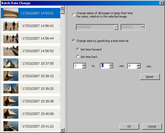
If you have wrongly entered the time, or forgotten to change the hour, Picture Motion Browser has a useful ‘Batch Date Change’ function which lets you correct the entire shoot instantly to the nearest second.
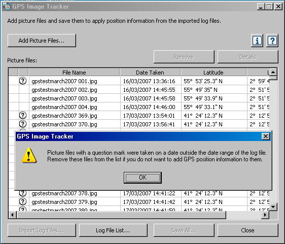
With the time corrected, you then use Image Tracker to associate GPS data with the files. It will identify those shots for which there is no logged position within 15 seconds, and allows you to remove them from the list.
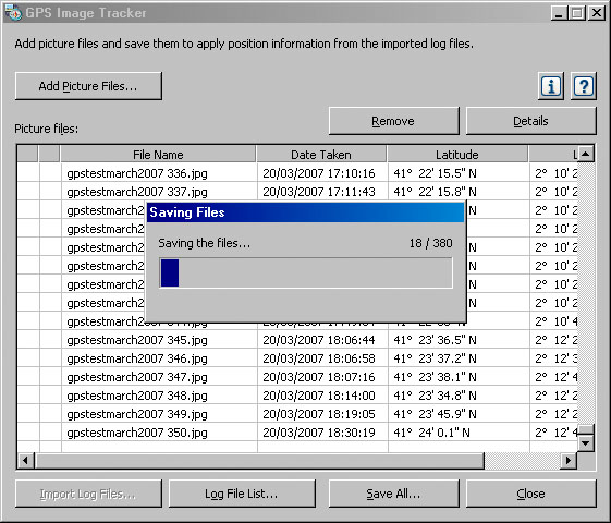
Finally, you save the GPS map data back into the ‘metadata’ fields of your JPEGs. Once this is done, your images have a permanent record of where they were taken embedded in each individual shot.
The last part of the sequence is to view the images in Picture Motion Browser. This program was updated with a plug-in by the installation software, and now shows a small symbol on each thumbnail which has GPS data (example on the thumbnail seen below, top left of the browser). A map icon appears on the taskbar of the program.
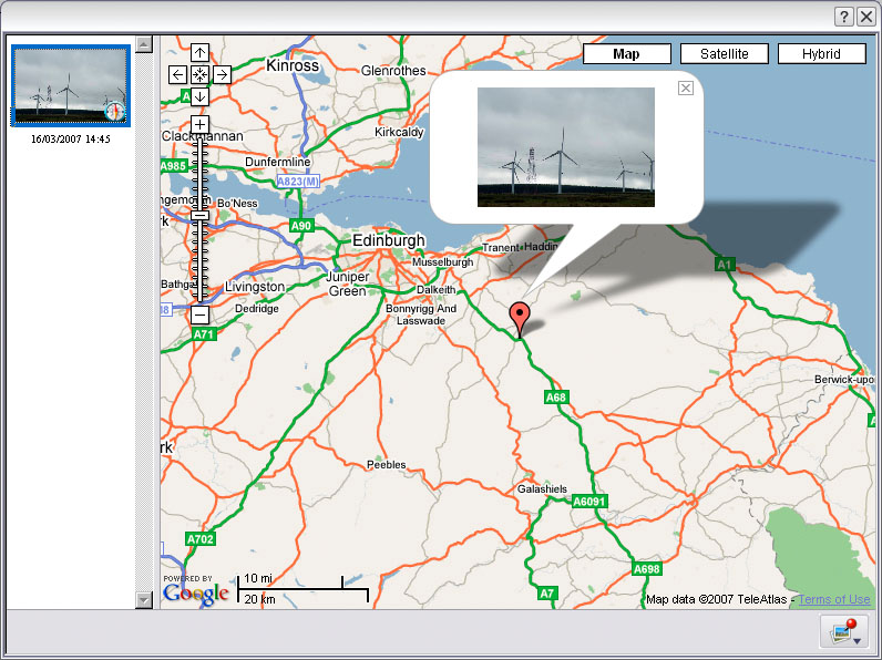
Clicking this icon when a GPS-active image is selected takes you directly to a Google-powered on line map, which starts off zoomed out to show an entire region (above). Your shot is shown as a thumbnail tacked to the map like a small flag. When you zoom in, you can go down as close as a single field, street or square and read street names, rivers and similar features from the map. It’s the same kind of software which is used in Satnav units for cars.
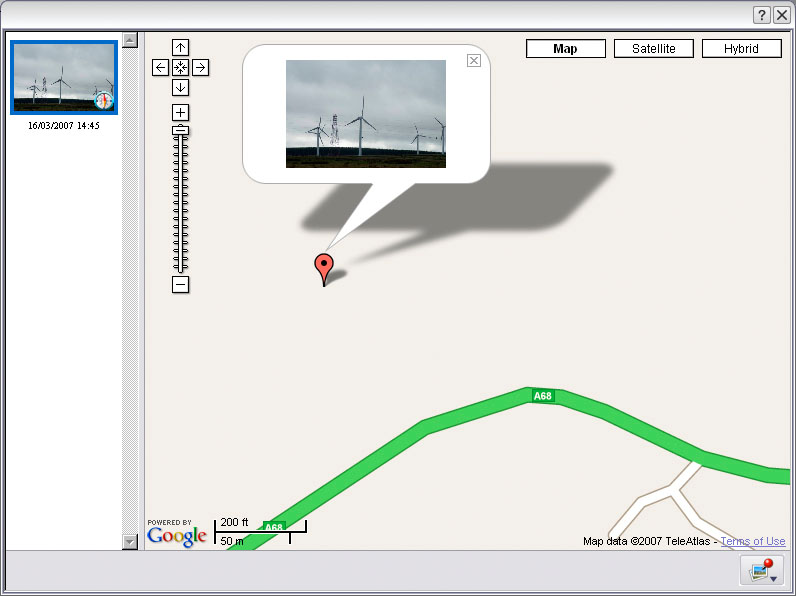
However, fine though this zooming in may look, the first thing I noticed was that the position recorded did not match any place the CS1 unit has been – regardless of 15 second intervals. I was stuck in a traffic queue and still in my car. I did not leave and enter the open moorland area indicated by the map position! See later comments and the Barcelona example.
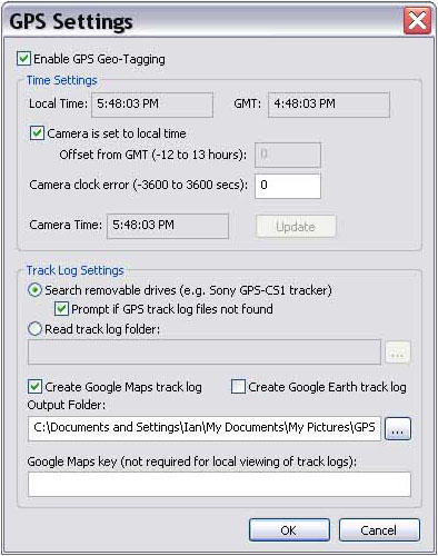
What if you do not own a Sony Alpha 100 camera? Chris Breeze’s excellent independent raw converter and file manager, BreezeBrowser Pro, supports the GPS-CS1 (see GPS Preferences and Setup dialog above – screen shots provided by courtesy of Ian Leonard). Visit www.breezesys.com for informaton. The latest downloader works with the GPS-CS1 log files (manually downloaded and saved) to add data to images as you copy them from your card or camera. Unlike the Sony software, it will embed GPS data in raw files.
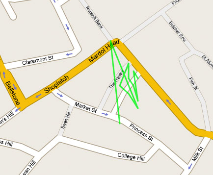
This map shows a track – one of the functions available through the Breeze software, linking the timed coordinates to produce a path which the tracker has followed. Ian Leonard was photographing Shrewsbury town centre, and walked round the blocks, not through buildings; it can’t record the path taken, only the spots where the images were shot.
No doubt many more programs will arrive offering a GPS support with on-line linking to maps, and in Sony’s literature, it’s made clear that the support provided now may not be permanent. A different map provider may be involved, or it’s possible a subscription might be needed to a map service.
Some digital SLRs now support add-on GPS devices – the Fuji S5 Pro is one – and with Sony clearly aware of this game, I reckon we will see a GPS module option for a future Sony DSLR in the next year or two. That will then record the position of your shots from the day you buy the camera, embedded in the file from the instant you shoot.
In practice
Testing the GPS-CS1 in Scotland and Barcelona, we found that drop out of signal was common and on any given shoot a quarter of the shots might be untracked. It was very rewarding and interesting to see the map pop up for others.
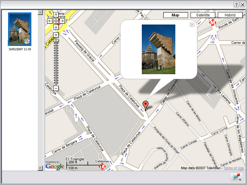
The accuracy of position was never all that wonderful; the statue to the first President of Catalunya was positioned by GPS as if on the sidewalk outside El Corte Ingles, and my car appears to have been in the middle of a field not on the A68 (the first example earlier in this article). The error seemed to be variable, and was not due to the 15 second timing margin in all cases. The field off the A68 was never on my itinerary!
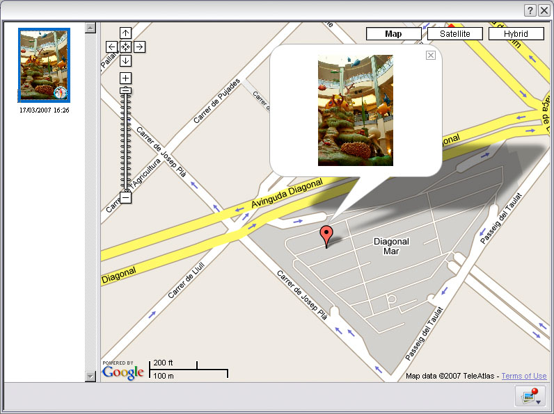
Despite this, the GPS-CS1 proved capable of recording inside the depths of the Diagonal Mar shopping centre in Barcelona, which is actually below ground level at the point where the picture was taken. The actual location was the small ring-shaped detail on the map of the centre’s hallways, so again, it was not accurate as I did not move from this position for several minutes, and it is not a time-lag error.
The GPS-CS1 constantly lost signal both in Scotland and Barcelona. It was not easy to understand why it should be unable to pick up a signal on an open beach, or on the highest elevation of the road out of Edinburgh, but succeed in finding a signal in the depths of a shopping mall or in narrow city streets. To be truly useful, it needed to be as sensitive as a good in-car satnav system, and with its tiny aerial and low power receiver, it isn’t. Other uses report fewer problems, possibly because they have used a GPS-CS1 in an area where a very strong signal has prevailed.
For the price – £99 from SonyStyle UK or Sony shops, under £70 from some internet sources in the UK, £45 from Hong Kong – this little device could be a great asset. I would not use it in city streets where I knew perfectly well where I was, or at any fixed location event. Wandering the hills, getting out of the car for a landscape view on a long drive, travelling in unknown villages and beaches abroad – that’s where the GPS reference can help you pin down the place.
Specifically, it could identify villages, beaches, churches, landmarks, hills or mountains (combined with a compass to enable you to record the direction you were shooting in). A future GPS equipped DSLR needs to have this unit built-in with recording times directly linked to shutter release, and also a device to record compass orientation, and angle of elevation of the lens, along with focal length data (present in the EXIF). Given this data, we could have a map which showed not only the camera position, but the angular field photographed in the direction the shot was taken. That really would nail identification precisely.
I will be taking the GPS-CS1 with me again on trips to areas I don’t know, but using the normal notebook and quick JPEG snaps method to reinforce details of each shot location.
This PC-only, slightly flaky and rather restricted technology is of course rocket science but it’s the sort of rocket science we can all use!
Following this review, I have received some useful information from other users about different applications which can read the GPS data file from the GPS-CS1. Robert Lynch, writing on the Minolta Yahoogroup, gives this overview – still omitting any native Mac functionality, but the current Intel Macs can run Windows, and we shall be moving the software from our Windows machine shortly to a new Mac iMac 24″ with Parallels Desktop.
This is Robert’s post:
“The unit will work with Intel Macs running OS X 10.4.9 or later. It will mount as a standard USB drive. PowerPC Macs are not supported. Of course, the software is still Windows only.
“There is a version called GPS-CS1KA that Sony is now selling that includes the Picture Motion Browser software for use with other cameras that don’t include it. The product name is changed from “for CyberShot Digital Cameras” to “for Most Digital Still Cameras”. It is available at Sony Style in the US and Amazon in the US and UK.
“The CS1 produces plain text log files in standard NMEA sentence structure, as many GPS devices do. (Read about it here: http://www.gpsinformation.org/dale/nmea.htm) Any software that understands the format will be able to work with the logs, so anything that runs on a Mac that can use them will work with the device if you can mount it as mentioned above.
“If you already have a GPS unit that records waypoints, you can try something like RoboGEO 5.0 (free to try, Windows only, sorry) to embed the data in JPEGs and then use GPS Visualizer (http://www.gpsvisualizer.com/) to make Google Maps (works with Macs! Free!)
“If you absolutely must do your geocoding on a Mac, try HoudahGeo (Mac OS X 10.4.8) (http://www.houdah.com/index.html) or PhotoGPSEditor (http://www.mmisoftware.co.uk/pages/photogpseditor.php).”
Many thanks to Robert for this research.
– David Kilpatrick

Pingback: Sony GPS-CS1 tracker and software | Photoclub Alpha « Site Super Tracker